


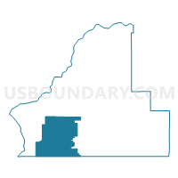
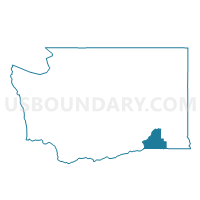
Touchet Voting District, Walla Walla County, Washington
About
Outline

Summary
| Unique Area Identifier | 689962 |
| Name | Touchet Voting District |
| County | Walla Walla County |
| State | Washington |
| Area (square miles) | 138.95 |
| Land Area (square miles) | 138.88 |
| Water Area (square miles) | 0.07 |
| % of Land Area | 99.95 |
| % of Water Area | 0.05 |
| Latitude of the Internal Point | 46.07463530 |
| Longtitude of the Internal Point | -118.72521520 |
Maps

Graphs
Select a template below for downloading or customizing gragh for Touchet Voting District, Walla Walla County, Washington


Neighbors
Neighoring Voting District (by Name) Neighboring Voting District on the Map
- Eureka Voting District, Walla Walla County, WA
- Frenchtown Voting District, Walla Walla County, WA
- Ice Harbor Voting District, Walla Walla County, WA
- Wallula Voting District, Walla Walla County, WA
Top 10 Neighboring County Subdivision (by Population) Neighboring County Subdivision on the Map
- Pendleton CCD, Umatilla County, OR (19,339)
- Burbank CCD, Walla Walla County, WA (3,894)
- Waitsburg CCD, Walla Walla County, WA (2,821)
- Touchet CCD, Walla Walla County, WA (2,059)
- Athena CCD, Umatilla County, OR (1,906)
- Eureka Flat CCD, Walla Walla County, WA (1,330)
- Umapine CCD, Umatilla County, OR (875)
Top 10 Neighboring Place (by Population) Neighboring Place on the Map
Top 10 Neighboring Unified School District (by Population) Neighboring Unified School District on the Map
- Walla Walla School District, WA (37,579)
- Milton-Freewater School District 7, OR (11,750)
- Columbia School District, WA (3,892)
- Touchet School District, WA (1,124)
- Helix School District 1, OR (432)
Top 10 Neighboring State Legislative District Lower Chamber (by Population) Neighboring State Legislative District Lower Chamber on the Map
- State House District 16, WA (154,830)
- State House District 58, OR (62,100)
- State House District 57, OR (57,718)
Top 10 Neighboring State Legislative District Upper Chamber (by Population) Neighboring State Legislative District Upper Chamber on the Map
Top 10 Neighboring 111th Congressional District (by Population) Neighboring 111th Congressional District on the Map
Top 10 Neighboring Census Tract (by Population) Neighboring Census Tract on the Map
- Census Tract 9504, Umatilla County, OR (6,256)
- Census Tract 9200, Walla Walla County, WA (5,224)
- Census Tract 9201, Walla Walla County, WA (4,880)
- Census Tract 9503, Umatilla County, OR (2,781)
Top 10 Neighboring 5-Digit ZIP Code Tabulation Area (by Population) Neighboring 5-Digit ZIP Code Tabulation Area on the Map
- 99362, WA (41,056)
- 97862, OR (11,666)
- 99323, WA (3,684)
- 99360, WA (1,350)
- 97835, OR (361)
- 99363, WA (216)